跳到主要內容區塊
:::

土牛溝楊梅段

跟土牛溝楊梅段有關的相片,共3張
跟土牛溝楊梅段有關的相片,第1張
跟土牛溝楊梅段有關的相片,第2張
下載數位物件授權: CC BY-NC

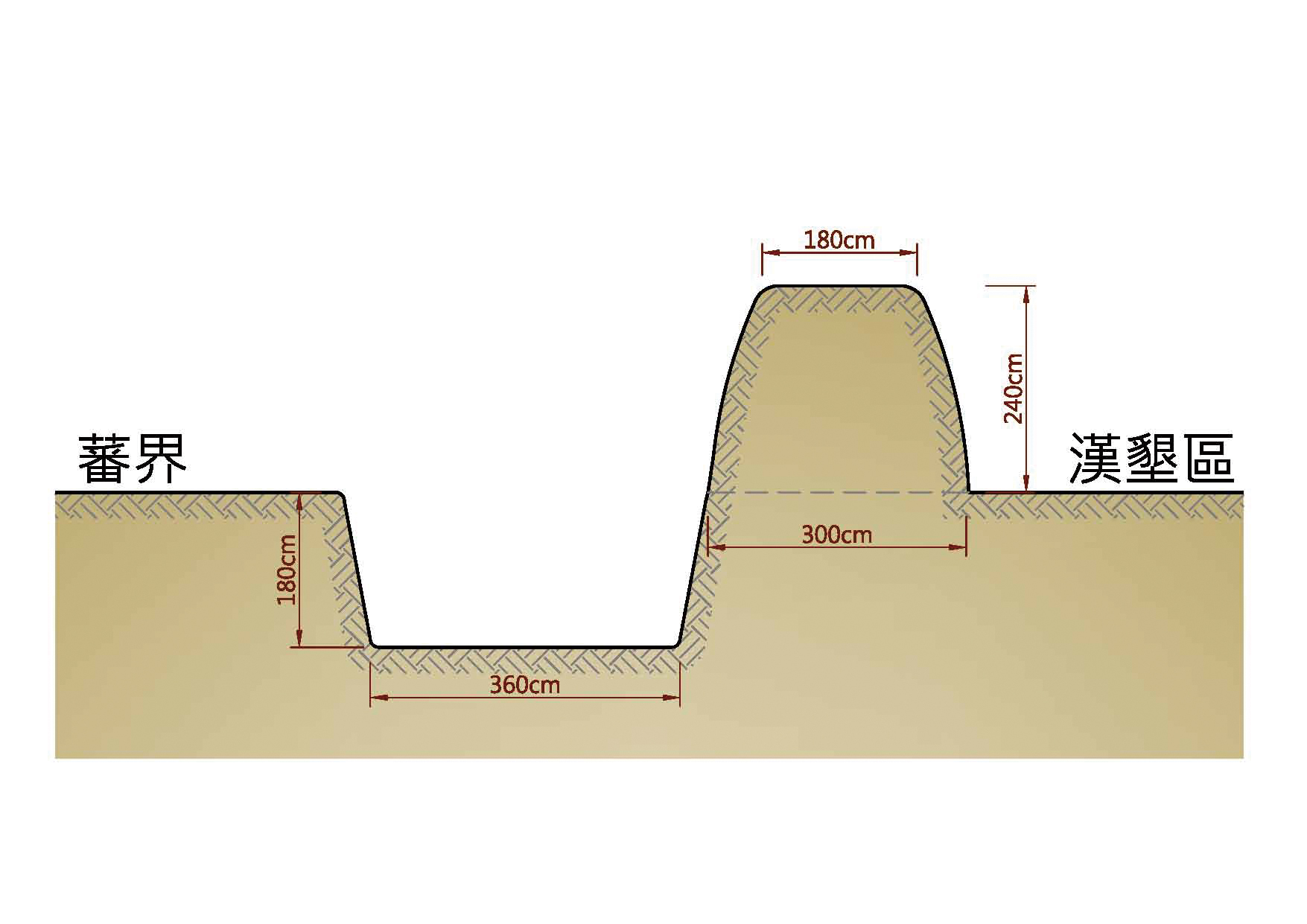
  土牛溝楊梅段位於永平工商東北側山坡上保留形貌完整,長約100公尺。土牛溝又稱「土牛」或「土牛紅線」,為清康熙61年(1722)朱一貴事件後由官府劃定,目的是避免漢人與原住民聯合反清,或是雙方為墾地發生流血衝突而設的界線,初時立碑為界,後來演變成挖溝。挖溝前先立石,繼而挖出深溝,一旁堆高溝土成界,由於成堆的溝土形似牛背,故稱「土牛溝」,溝寬與溝深一般在3公尺左右。

  這條界線最初南起屏東枋寮,北至基隆獅球嶺,界線以西的居民為漢族及歸化的熟番(平埔族),要繳人頭稅,且不可至溝東越墾;溝東為生番(原住民)領域,不受清政府管轄。

  到了乾隆年間,土牛溝演變為劃分漢民、平埔族與原住民的界線,主要目的為防止漢番衝突。

  土牛溝自乾隆26年(1761)正式掘溝築牛後,已在臺灣歷經250年以上歷史。目前全臺土牛溝殘跡以楊梅段保存最為完整。

政府資料開放授權條款-第1版(OGDL 1.0) 政府資料開放授權條款-第1版(OGDL 1.0)
 複製授權引用資訊
描述文字授權: OGDL

基本資訊

原始資料連結原始資料連結
資料來源機關收存系統
主題分類其他
建檔單位桃園市政府
所在地-地址
桃園市楊梅區青山二街321巷
免費進場
史料原文/譯文
The Yangmei section of Qing Dynasty Border Moat is well-kept, 100 meters long, 3 meters in width and depth, to the northeast of YongPing Vocational School. Also named "earthen oxen," the Qing government set it up to avoid further conflicts between the Han people and the Taiwanese aboriginals similar to 1722's incident. The Hans used rocks as borders, dug deep trenches and applied the dug dirt to form borders. Its name came from the earth dug and piled next to the trench that looks like an oxen's curved back. The original moat went as far south as Pingdong and as north as Keelung; the Hans to the west were not allowed to use lands to the east, whereas the indigenous people to the east were not ruled by the Qing government. It was meant to keep them from mutual intrusion and attacks. Since 1761, such kind of trench has been around for over 250 years. This stretch is the best-kept original section of the Moat in Taiwan.
所在地-緯度
24.920675
所在地-經度
121.174222
是否開放
所在地-名稱
臺灣
撰寫者
桃園市政府文化局

關鍵詞

本網站使用Cookies收集資料用於量化統計與分析,以進行服務品質之改善。請點選"接受",若未做任何選擇,或將本視窗關閉,本站預設選擇拒絕。進一步Cookies資料之處理,請參閱本站之隱私權宣告