跳到主要內容區塊

:::
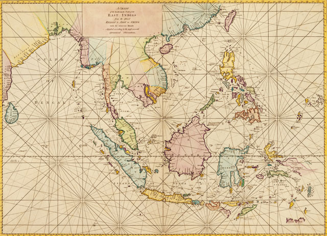
東南亞航海圖A chart of the easternmost part of the East Indies from the islands Zeloan to Amoy in China with the adjacent islands. Adjusted according to the most accurate astronomical observations


本圖繪者為William Herbert(1718-1795),這張東南亞航海圖收錄自他在1758年出版A New Directory for the East Indies一書中。這張航海圖範圍,北從台灣、廈門,南到帝汶島(Timor)、印尼群島等,西到印度南端斯里蘭卡(Zeloan)正表示在歷史上,臺灣與東印度,或東南亞地區的關係,相當密切。
基本資訊
- 原始資料連結
- 資料來源
- 主題分類
- 建檔單位
- 創作者William Herbert
- 出版者William Herbert A Chart of the Easternmost Part of the East Indies from the Islands Zeloan to Amoy in China with the adjacent Islands. Adjusted according to the most accurate Astronomical Observations, 1758
- 創作日期出版/發行日期:1758
- 作品語文英文
- 全集/系列名臺史博文物數位典藏
- 相關地點東南亞 台灣 廈門 印尼 印度 臺灣
- 地圖


引用資訊
網站公告
「國家文化記憶庫」滿意度調查開跑,填寫即抽 500 元超商商品卡!
親愛的使用者,您好!
為了打造更貼近您需求的網站服務、提升核心功能的使用體驗,我們誠摯邀請您撥冗填寫這份滿意度調查問卷,預計需時約 6-8 分鐘。您的寶貴意見,無論是讚美或建議,都將成為我們未來改進網站的重要依據,幫助我們將這座線上記憶寶庫打造得更友善、更豐富、更好用!
問卷連結: https://forms.gle/tyQLdiCmBHJidpLp7 (點擊前往填寫)

本網站使用Cookies收集資料用於量化統計與分析,以進行服務品質之改善。請點選"接受",若未做任何選擇,或將本視窗關閉,本站預設選擇拒絕。進一步Cookies資料之處理,請參閱本站之隱私權宣告。