跳到主要內容區塊

:::
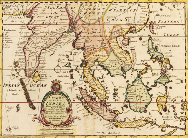
A new map of the east Indies, taken from Mr. Deferʹs map of Asia, showing their chief divisions, cities, towns, ports, rivers, mountains & c. dedicated to his highness Willaim Duke of gloucester


本圖標題「東印度群島新圖A new map of the east Indies」,圖下方文字說明此圖是根據法國製圖師Nicolas de Fer(1646-1720)亞洲地圖所重新繪刻。本圖繪刻者Edward Wells(1667-1727)身兼數學家與地理學家的身份,任教於英國牛津大學。Wells製作的地圖主要為教學之用,圖面簡單清晰,較少複雜地名的註記,並且基於教學需要而另行繪製偏重歷史地圖詮釋或著重地理知識的版本。這張東印度群島新圖收錄自他在1700年所出版地圖集A New Sett of Maps中。由此圖可想像到臺灣與東南亞的關係密切,更有意思的是,臺灣島之名,除了福爾摩沙島(I. of Formosa)外,此圖又標記,又名:Bell I(sland)(鐘形花冠島?),不知是否為美麗的誤會?
基本資訊
- 原始資料連結
- 資料來源
- 主題分類
- 建檔單位
- 創作者Edward Wells
- 出版者Edward Wells A New Sett of Maps 1700
- 創作日期出版/發行日期:1700
- 作品語文英文
- 全集/系列名臺史博文物數位典藏
- 相關地點印度 法國 亞洲 英國 台灣 東南亞 臺灣
- 地圖


引用資訊
網站公告
「國家文化記憶庫」滿意度調查開跑,填寫即抽 500 元超商商品卡!
親愛的使用者,您好!
為了打造更貼近您需求的網站服務、提升核心功能的使用體驗,我們誠摯邀請您撥冗填寫這份滿意度調查問卷,預計需時約 6-8 分鐘。您的寶貴意見,無論是讚美或建議,都將成為我們未來改進網站的重要依據,幫助我們將這座線上記憶寶庫打造得更友善、更豐富、更好用!
問卷連結: https://forms.gle/tyQLdiCmBHJidpLp7 (點擊前往填寫)

本網站使用Cookies收集資料用於量化統計與分析,以進行服務品質之改善。請點選"接受",若未做任何選擇,或將本視窗關閉,本站預設選擇拒絕。進一步Cookies資料之處理,請參閱本站之隱私權宣告。