跳到主要內容區塊

:::
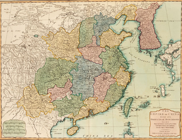
中國地圖(The empire of China)


這張「中國地圖 The empire of China」是由英國製圖家Robert Laurie(1755-1836) 與 James Whittle(1757-1818)兩人於18世紀末出版。地圖的全部名稱以英文寫著:The empire of China, with its principal divisions; drawn from the surveys made by the Jesuits; with improvements and additions from the maps of Mons. D’Anville,顯示此圖也是依據18世紀初耶穌會教士測繪中國圖所繪刻。這批耶穌會教士係奉康熙皇帝之命測繪大清帝國的版圖,從1708年展開測繪工作到1717年完成,歷時約十年,他們採用三角測量技術,測得全中國630多個經緯點,成為此後中西地圖製繪中國地圖的重要參考。
基本資訊
- 原始資料連結
- 資料來源
- 主題分類
- 建檔單位
- 創作者Robert Laurie & James Whittle
- 出版者Robert Laurie James Whittle
- 創作日期出版/發行日期:1794
- 作品語文英文
- 全集/系列名臺史博文物數位典藏
- 地圖


引用資訊
網站公告
「國家文化記憶庫」滿意度調查開跑,填寫即抽 500 元超商商品卡!
親愛的使用者,您好!
為了打造更貼近您需求的網站服務、提升核心功能的使用體驗,我們誠摯邀請您撥冗填寫這份滿意度調查問卷,預計需時約 6-8 分鐘。您的寶貴意見,無論是讚美或建議,都將成為我們未來改進網站的重要依據,幫助我們將這座線上記憶寶庫打造得更友善、更豐富、更好用!
問卷連結: https://forms.gle/tyQLdiCmBHJidpLp7 (點擊前往填寫)

本網站使用Cookies收集資料用於量化統計與分析,以進行服務品質之改善。請點選"接受",若未做任何選擇,或將本視窗關閉,本站預設選擇拒絕。進一步Cookies資料之處理,請參閱本站之隱私權宣告。